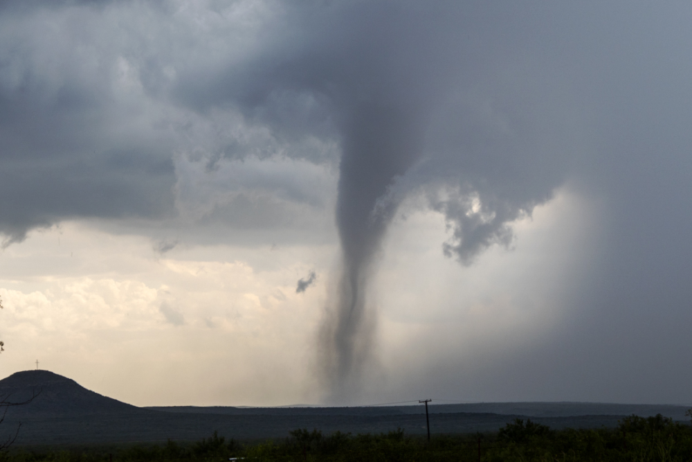
Almost 70 million people from Texas to Michigan were under threat of severe weather Tuesday. These alerts came after more than 30 people died over the weekend, following a series of tornadoes that hit the South and Midwest. At least 50 tornadoes touched down across seven different states, leaving widespread power outages and property damage in their wake.
Tornadoes are most active between April and June, but this year is already off to an active start.
For more on what to expect this tornado season and what’s causing these widespread outbreaks, the Standard spoke with Matt Lanza. He’s a meteorologist and managing editor at Space City Weather in Houston. Listen to the story above or read the transcript below.
This transcript has been edited lightly for clarity:
Texas Standard: Tell us about the tornado activity we’ve seen across the South during this season. Is this considered unusual?
Matt Lanza: Yeah, I think we’ve had quite a bit of it and it feels like it’s really early. To be honest, it’s not that uncommon for it to get started a little bit early. Sometimes you can have very active Marches in addition to some active Februarys, too. We don’t really get into the heart of things, as you said, until April or May. Certainly, things have started off on a loud note.
It’s been a few years since we’ve had a year that has been like this. It seems like we’re constantly seeing these outbreaks happen, and they’re hitting communities. So, it’s not as if they’re just going through open fields or very rural areas. They’re actually hitting towns. And that’s some bad luck. It has definitely gotten off to a little bit of a more active start than we were hoping for this year.
How did these storms this year compare to previous years?
We’ve had a few big ones this year, that’s for sure. There’s definitely been some EF4 tornadoes. We usually get a few of those each year. But seeing those hit communities and causing so much devastation and loss of life is a little jarring, especially given that the last couple of years haven’t had quite as much of that.
I think 2020 had a little bit of that, and 2011 is a standout. That was the year that had major tornadoes in Alabama, Mississippi and Joplin, Missouri. So, it feels like we are on one of those types of trajectories right now, which means I don’t think we’re necessarily done with a severe weather season by any means.
What causes a widespread tornado outbreak?
You need to have a clash of air masses. If you’ve been paying attention to the weather this winter and spring, what we’ve seen is California constantly getting hit with storms. There’s been a lot of talk about storminess in the West. What’s happened is we’ve had this trough of low pressure over the West, which means it’s been cold out there, with some very cold air in parts of the interior West.
So, you’ve got that cold air and you’ve got the Gulf of Mexico, which is running about 3 to 6 degrees above normal. You’ve got a lot of warm air out in front of that. If you’ve been in Texas, it’s been pretty warm at times this spring and even late in winter. You’ve got that clash of air masses and it just happens to take place with some oscillation between the plains and parts of the interior Southeast. It’s that battleground where you’ve got that clash of air masses that sets things up for more severe weather outbreaks.
I think what’s really helping this year and making it a little bit stronger is the fact that the West has been very cold and it’s been very active and stormy. So, we keep getting things that can cause storms and then you’ve got that warm gulf that is certainly not helping matters by any means.
It’s not just tornadoes threatening Texas. We’ve seen some record high temperatures and high winds increasing the risk of wildfires. What is the latest forecast, and what are you watching for?
As we go through today, we’ve got some very critical fire danger in parts of West Texas because the air mass is incredibly dry. The relative humidity in parts of interior Texas on Monday was down to 1%. That is, there’s almost no moisture in the air at that point. This is very, very dry air and even unusual for Texas standards. So, we have to watch for wildfire danger. Each time you get one of these storms, you usually get some winds out ahead of it as they develop. So, we start to ramp up that wildfire risk.
As we go into the weekend, we see the weather pattern start to change a little bit and we get a cold front all the way down to the Gulf Coast. Then, we get some heavy rain across parts of southern and eastern Texas that have not had a ton of heavy rain lately. So, we’ve got a few things to watch.
Thankfully, the severe weather risk in Texas doesn’t look too crazy at this point for the next few days at least. But, you never know. Any of these storms are always capable this time of year producing some strong or severe weather. We’ve got to watch out for that. But the greatest risk of severe weather will stay to the east of Texas.