Texas’ power grid will likely be tested for the first time this year, as a major winter storm is expected to bring cold temperatures, ice and even snow to portions of the state. And that means concern over potential downed power lines and other hazards.
The Electric Reliability Council of Texas, or ERCOT, which manages the state’s power grid, predicts electricity demand to peak on Friday at a level just under what was seen during last year’s February freeze.
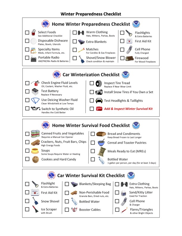
The good news is that this storm is predicted to be milder than last year’s. But Todd Beal, a National Weather Service emergency response specialist for the Southern Region Regional Operations Center in Fort Worth, says it’s still important for Texans to prepare now. Listen to the interview with Beal in the audio player above or read the transcript below to learn more about the forecast for the next few days and tips for preparation. And scroll down to see the National Weather Service’s Winter Preparedness Checklist.
This interview has been edited lightly for clarity.
Texas Standard: What does the forecast look like the next couple of days across the Lone Star State?
Todd Beal: We do have a winter weather event that will impact the state of Texas here over the next couple of days. It looks like we’ll see winter weather begin late Tuesday night up in the Panhandle. And then as we go through Wednesday into Thursday, that wintry precipitation will spread south and eastward, maybe as far south as South Central Texas and the Austin area.
What we’re looking at for snowfall, the greatest snowfall amounts will be across the Panhandle and to Northwest Texas, where we could see upwards of 3 to 5 inches, maybe some locally higher amounts of snow over those areas. As you move further south and east and to the southern portions of the state, we could see more in the way of ice.
So, our corridor of ice that we’re concerned about is from roughly just north of San Antonio to Austin, up towards the Dallas-Fort Worth metroplex, with the greatest accumulations of ice potentially along the Red River north of the Dallas-Fort Worth area. That’s where we could see some problematic ice accumulations.
What about folks east of Interstate Highway 35? If you’re in the Houston area or if you’re in Beaumont or farther east, will this storm to move into that region as the week progresses?
Right now, there’s no winter precipitation forecast for those areas, but they will see some locally colder temperatures as we get towards the latter part of the week.
With winter conditions expected for a good part of the state, some folks may feel nervous thinking of last year’s storm. What does the forecast tell you about how this storm differs from last year’s?
The duration is the first thing that sticks out to us. The length of time that we’ll see those below-freezing temperatures will not be as long as last year. For instance, on Friday, we already have temperatures rebounding up above freezing in some portions of the state. However, the concern will be that we will see temperatures fall back below freezing during the overnight hours through the weekend. As I mentioned, though, the length of time that we’ll see those freezing temperatures will not be as great as we saw last year.