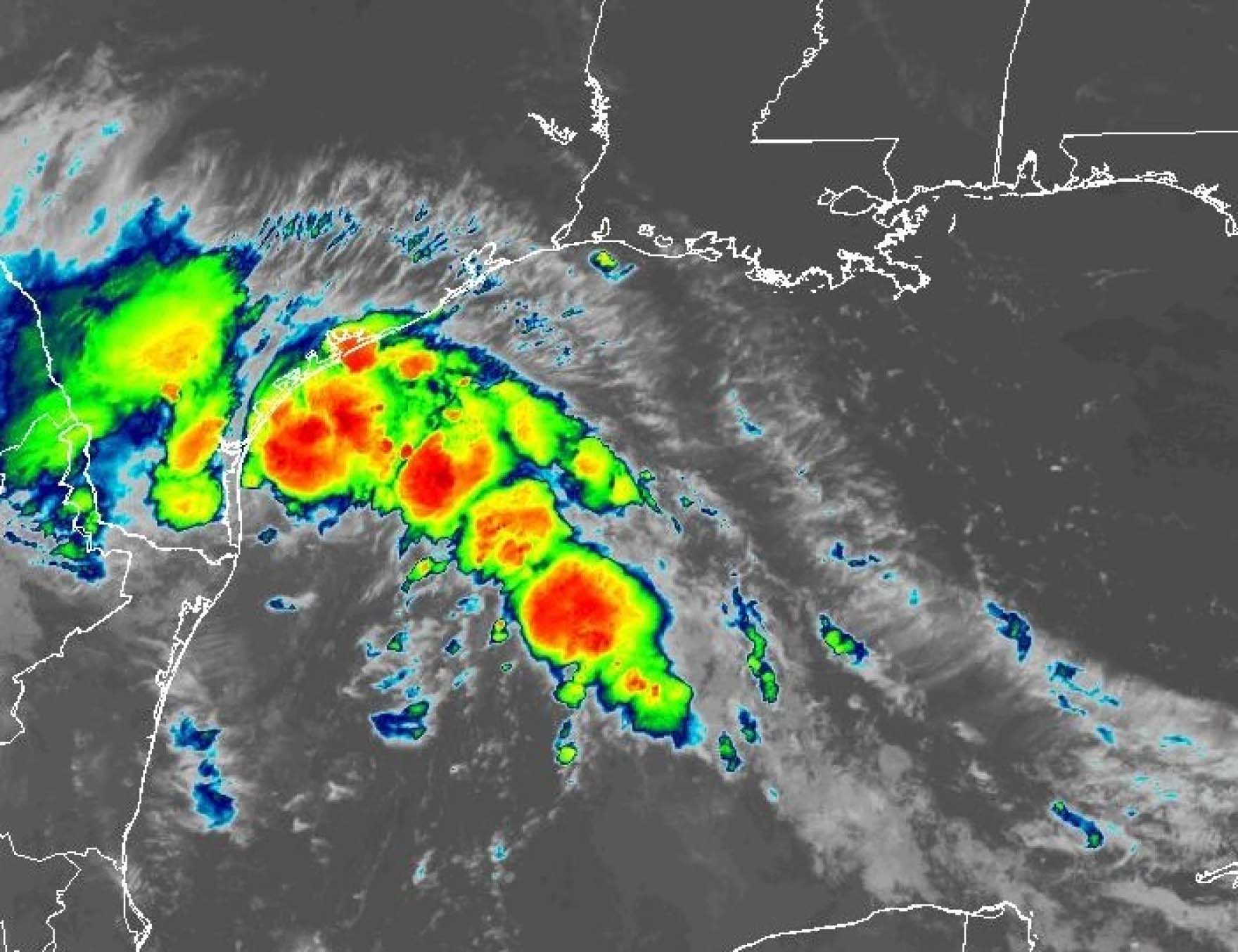
Tropical Storm Harold made landfall in South Texas on Tuesday and is expected to hammer the coast with up to 7 inches of rain heading into Wednesday.
Gov. Greg Abbott ordered the deployment of state emergency response resources and an increase in the readiness level of the state’s emergency operations center ahead of the storm, which also brings with it the threat of flash flooding and damaging winds.
Matt Lanza, managing editor of Space City Weather in Houston, joined Texas Standard with the latest forecast.
This transcript has been edited lightly for clarity:
Texas Standard: For some, I know this could mean a much-needed break from the heat and the drought, obviously. But we’re talking about a tropical storm here; this isn’t a hurricane. Could you give us some sense of the scale of what Texans could be in for today and tomorrow?
Matt Lanza: Yeah. So this is probably going to be the rare case where a tropical system making landfall in Texas is actually a good thing – for most people it will be. There will certainly be some wind; there may be a couple of isolated tornadoes as well, as you always get with tropical systems as they come inland. But for the most part, it’s the rain that’s going to be the the main issue with this. And in South Texas, like much of Texas, they need it. And so this will actually help ease conditions a little bit down there that have been so dry this summer.
I remember – and I know a lot of our listeners remember – Hurricane Harvey, which, bore down over Texas and maintained a kind of tropical storm intensity the whole time while it was inland over Texas. What would you say to people who say, well, you know, watch out, we don’t need to take this for granted – because this is, after all, a tropical storm, and it can bring rain in rapid bursts, which can certainly wreak havoc.
Yeah, for sure. And, you know, you always have to take these things very seriously, and you can get some heavy rain. The good news with this is that it is moving very fast. Unlike Harvey, which actually slowed down at landfall, this one’s going to keep going at the same clip that it’s been moving across the Gulf, which is to say about 15 to 20 miles an hour – which doesn’t sound very fast, but for a tropical storm, that’s very fast.
And so this is going to be into South Texas this morning and this afternoon and then out by tonight and tomorrow morning. So by tomorrow, it may be like nothing really ever happened.
» GET MORE NEWS FROM AROUND THE STATE: Sign up for our weekly ‘Talk of Texas’ newsletter
I was noticing that folks who live on a line roughly, it seems, like north of I-10 as it stretches across the state, you’re not going to see much of a difference. It’s still going to be quite hot today, and you’re not going to get a lot of rain. Which areas could be most heavily impacted?
Yes. So it’s going to be areas south of I-10, particularly, I think in the Corpus Christi area, that you’ll see a good bit of rain down there. We’ve already seen a good bit of it this morning. There’s more coming for this afternoon. The Valley will see probably more scattered rain off and on, intermittent but heavy at times for sure.
But the bulk of this moisture will probably travel near and south of Corpus Christi and then straight west toward Laredo and into northern Mexico. So that’s where we could see somewhere on the order of 2 to 4 inches, maybe as much as five or six inches in some of the heavier bands. And certainly it will come down very fast. You’ll probably have some roadway ponding down there and things like that. But yeah, like you said, north of I-10, next to nothing from this.
Should coastal residents, especially those around the coastal bend, be taking steps right now to prepare for this? What would you advise?
Yeah, for folks that are there in the coastal bend near the coast, you kind of have to hunker down at this point. The storm is here, like we said, it’s moving so fast that, you know, yesterday we started talking about it [as] a potential tropical storm, and today it is, and now it’s moving ashore. So, you know, you’re kind of stuck at this point.
You know, hang tight; ttay close. It’s one of those situations where it’s a good idea to have your phone charged and things like that. You’re probably not going to be dealing with anything too serious. But the power could always go out because of some of the gustier winds in the thunderstorms, which could be as high as 40 or 50 miles an hour. Certainly notable and capable of producing some power outages. So have your phone charged and just be ready in case the power goes out.
Are there any warnings have been issued by the National Weather Service so far, to your knowledge?
Yeah, we’ve had a couple of tornado warnings, I think, in parts of South Texas. These are very brief tropical tornadoes that’ll spin up. And they last for maybe five or 10 minutes and then they dissipate. But every now and then you can pick them up on radar and they’ll warn on them. So we’ve seen a couple of those.
I don’t know if anything has been confirmed yet, but there’s definitely been some signatures on radar, and we may see a little bit more of that throughout the day today. So certainly something to also be aware of.
We’ve been reporting quite a bit on the wildfires that officials are trying to deal with statewide. Could this help in those efforts, or not so much?
It’s kind of a two-pronged thing. So on the one part, for South Texas, this will help with the rain. But on the other hand, we may actually have a little bit of enhanced fire danger today because high pressure sitting to our north and then this tropical storm going into the south parts of Texas – in between, it’s a little bit breezier than it has been maybe on some days.
So you’ve got some breezy conditions; you’ve got a little bit drier air north of I-10. That’s usually a combination, particularly with such a dry ground, that we could have wildfires. I know there are some red flag warnings that are for fire danger today. So folks really do need to be aware and careful of that in the central parts of the state, particularly along and north of I-10, to the north of the path of this tropical storm.